
On November 28, 1912, Albanian delegates at Vlorë declared independence from the Ottoman Empire. Within weeks, six European ambassadors sat down in London to decide whether that declaration would survive — and what shape the new state would take. The Balkan Wars had redrawn southeastern Europe overnight, and the Great Powers needed to agree on who got what before the map hardened.
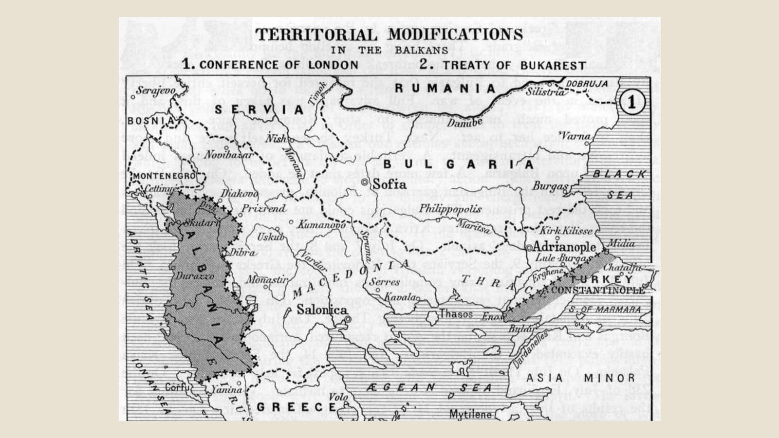
The Conference of London ran from December 1912 through August 1913. It recognized Albanian sovereignty — a genuine achievement, given that all four of Albania’s neighbors wanted pieces of it. But the borders the conference drew left roughly half of the ethnic Albanian population outside the new state. Kosovo went to Serbia. Chameria went to Greece. Western Macedonia was divided between Serbia and Greece. Albanians were not at the table when these decisions were made.
That map, drawn in a London drawing room by diplomats serving six foreign governments, is largely still the map of Albania today.
Why the Conference Convened
The First Balkan War, which began in October 1912, dismantled Ottoman control over southeastern Europe in a matter of weeks. The Balkan League — Serbia, Greece, Montenegro, and Bulgaria — overran Ottoman positions across the peninsula. Serbian forces took Kosovo and pushed to the Adriatic coast at Durrës. Greek forces occupied much of Epirus, including Ioannina. Montenegrin troops besieged Shkodër.
The speed of the collapse created a crisis. If Serbia reached the Adriatic, Austria-Hungary would face a Russian-backed rival on its southern flank. If Greece absorbed all of Epirus, Italy’s influence in the eastern Mediterranean would shrink. If no Albanian state existed at all, the balance of power between the Triple Alliance (Germany, Austria-Hungary, Italy) and the Triple Entente (Britain, France, Russia) would tilt in ways neither side could accept.
Britain’s Foreign Secretary, Sir Edward Grey, convened the conference to prevent a regional war from becoming a European one. The ambassadors of all six Great Powers gathered at St James’s Palace. The question was not whether Albania should exist — it was how much of it the Powers would allow to survive.
The Six Ambassadors and Their Interests
The conference was not a negotiation between equals pursuing a fair settlement. Each power had specific strategic objectives that had nothing to do with Albanian demographics.
Britain (Sir Edward Grey, chair) aimed to prevent a general European war. Grey’s primary concern was maintaining the balance between the alliance blocs. He did not have strong preferences about Albania’s borders, but he wanted an outcome all six powers could accept.
Austria-Hungary (Count Albert von Mensdorff) was Albania’s strongest advocate at the table — not from altruism, but because a viable Albania blocked Serbian access to the Adriatic Sea. The Austro-Hungarian position was that Albania should be as large as possible, including Kosovo, to create a buffer against Serbian expansion.
Italy (Marquis Guglielmo Imperiali) generally aligned with Austria-Hungary in supporting a larger Albania. Italy wanted to prevent Greek expansion northward along the Adriatic coast and saw Albania as a future sphere of Italian influence.
Russia (Count Alexander Benckendorff) backed Serbia and Montenegro consistently. Russia’s Balkan policy centered on supporting its Slavic Orthodox allies. The Russian position was that Kosovo and much of northern Albania should go to Serbia and Montenegro — reflecting the territory those armies had actually conquered.
France (Paul Cambon) generally followed Russia’s lead on Balkan questions while trying to preserve the Entente relationship. France’s direct interests in Albania were minimal.
Germany (Prince Karl Max Lichnowsky) supported its Austrian ally but was willing to compromise. Germany’s chief concern was keeping the alliance system intact, not the specific Albanian borders.
The result was a negotiation shaped by European alliance politics. Austria-Hungary and Italy pushed for a larger Albania; Russia pushed for a smaller one. Britain and Germany mediated. France followed Russia. Albanian interests were advocated only insofar as they served the strategic calculations of Vienna and Rome.
Albanians Outside the Room
Ismail Qemali’s provisional government at Vlorë was not seated at the conference. Albanian representatives — including delegations sent by Qemali and by Albanian communities in the territories under dispute — traveled to London and submitted memoranda, but they had no vote and no formal standing.
The Powers treated Albania as an object of diplomacy, not a participant. The borders would be drawn according to what the six governments could agree on, not according to what Albanians wanted or where Albanians lived. This was consistent with the Great Power practice of the era — the Congress of Berlin in 1878 had similarly redrawn Balkan borders without consulting the affected populations — but for Albanians the consequences were especially severe because the territory under discussion was their homeland.
The Albanian delegation’s key argument was demographic: the four Ottoman vilayets with substantial Albanian populations (Shkodra, Kosovo, Manastir, and Janina) should form the basis of the new state. The Powers acknowledged the demographic data — Ottoman census records and European consular reports both documented Albanian majorities across much of the disputed territory — but demographics were secondary to the strategic bargain between the alliance blocs.
The Treaty of London: May 30, 1913
The Treaty of London, signed on May 30, 1913, ended the First Balkan War. The Ottoman Empire ceded nearly all its European territory west of the Enos–Midia line. The treaty established the framework for an Albanian state but did not fix its precise borders — that work was delegated to a separate international boundary commission.
The treaty’s provisions for Albania were deliberately vague. Albania was to be an “autonomous sovereign principality” under the guarantee of the six Powers. A European prince, approved by all six governments, would be selected to rule it. An International Commission of Control would oversee the new state’s administration during a transitional period.
What the treaty did not do was equally important: it did not specify Albania’s northern, northeastern, or southern borders. Those would be determined by commission, which meant further months of negotiation while Serbian and Greek forces remained in occupation of the disputed territories.
The Borders: What Was Lost
The boundary commissions worked through the summer and autumn of 1913. The Protocol of Florence, signed on December 17, 1913, fixed the southern border. Northern border decisions were made through a series of conference decisions and commission reports.
The final map left Albania with roughly 28,000 square kilometers and a population of approximately 800,000 — a fraction of the territory and population of the four Albanian-majority vilayets.
Kosovo
Kosovo, with its overwhelmingly Albanian-majority population, was assigned to Serbia. This was the single largest territorial loss and the one with the longest-lasting consequences.
Ottoman census data from the early 1900s recorded Albanians as the clear majority in the Kosovo Vilayet. Austrian and British consular reports confirmed these figures. The conference participants knew they were assigning an Albanian-majority territory to Serbia. They did it because Russia would not accept any outcome that denied Serbia its wartime conquests, and because Austria-Hungary — despite favoring an Albanian Kosovo — was not willing to go to war over the issue.
The assignment of Kosovo to Serbia in 1913 set in motion the century of conflict that followed: interwar colonization campaigns, World War II, the 1981 Kosovo protests, the revocation of autonomy in 1989, the 1998–1999 Kosovo War, and Kosovo’s 2008 declaration of independence.
Chameria and the Southern Border
The Protocol of Florence drew the southern Albanian-Greek border through the middle of Albanian-inhabited territory. Chameria — the coastal Epirus region stretching from Konispol to the Gulf of Arta — was assigned to Greece despite a substantial Albanian-speaking population, particularly among Muslims.
The Powers tried to balance competing claims. Gjirokastër and Korçë, both with significant Albanian populations, were assigned to Albania — against Greek wishes — after Austria-Hungary and Italy insisted. But the rest of Epirus south of the new border, including dozens of Albanian-speaking villages in Thesprotia and Preveza, went to Greece.
The 1913 border set the conditions for what came later: the interwar squeeze on Cham Albanian community life, the mass expulsion of Muslim Chams from Greece in 1944–1945, and the unresolved property and recognition claims that persist today.
Western Macedonia
The towns of Dibra (Debar), Gostivar, Struga, Tetovo, and surrounding Albanian-inhabited areas were assigned to Serbia, which after World War I incorporated them into the Kingdom of Serbs, Croats, and Slovenes (later Yugoslavia). These territories today form the western part of North Macedonia, where Albanians make up roughly 25% of the population.
The Preševo Valley — the towns of Preševo, Bujanovac, and Medveđa in what is now southern Serbia — was also placed outside Albania, creating another Albanian-inhabited enclave under Serbian administration.
Montenegro
Plav, Gusinje, and the Albanian-inhabited highlands east of Shkodër were assigned to Montenegro. Shkodër itself was awarded to Albania after a prolonged crisis — Montenegro had besieged and captured the city, and Austrian ultimatums were required before Montenegrin forces withdrew in May 1913.
The International Commission of Control
The conference established an International Commission of Control (ICC) to administer Albania during its transition to self-governance. The commission comprised one representative from each of the six Powers and one Albanian member.
The ICC arrived in Albania in October 1913 and set up its headquarters in Vlorë. Its task was to organize the new state’s finances, gendarmerie, courts, and civil administration from scratch — in a country with almost no existing state infrastructure, occupied by foreign armies in the north and south, and facing internal revolts.
The commission’s work was overtaken by events. The Northern Epirus crisis of early 1914 — a Greek-backed insurgency in southern Albania — consumed the commission’s attention. Prince William of Wied, the German prince selected to rule Albania, arrived in March 1914 and found a state that existed more on paper than on the ground. By September 1914, six months after his arrival, William left Albania amid the chaos of World War I. The ICC effectively ceased to function.
The Map That Still Shapes the Diaspora
The 1913 borders created the conditions for more than a century of Albanian displacement and emigration.
The immediate effect was instability. The Principality of Albania collapsed within six months of its founding. World War I brought five foreign occupations in four years. The interwar period produced Ahmet Zogu’s authoritarian kingdom, Italian economic penetration, and the 1939 invasion. Each phase pushed Albanians outward — first to the wider Balkans, then to Turkey, Egypt, and eventually the United States.
The territorial partition shaped the Albanian-American community from its origins. The Vatra Federation, founded in Boston in 1912, organized around the cause of Albanian territorial integrity. Fan Noli’s Albanian Orthodox Church, the newspaper Dielli, and the dense network of Albanian-American mutual aid societies in New England, New York, and Detroit all drew their founding energy from the conviction that the 1913 borders were unjust and that the Albanian nation was larger than the Albanian state.
That conviction has not changed. Albanian Americans from Kosovo, from Chameria, from western Macedonia, and from Albania proper share a common understanding: the borders drawn in London in 1913 were a political compromise made by six European governments to serve their own strategic interests, not a map of where Albanians actually lived.
Kosovo’s 2008 declaration of independence was, in part, the correction of the 1913 assignment — though the correction took 95 years and a war to achieve. The Chameria question remains open. The Albanian community in North Macedonia continues to negotiate its place within a state whose borders were drawn without Albanian consent.
For the Albanian-American diaspora — roughly one million people by community estimate, 230,000 by U.S. Census count — the 1913 Conference of London is not a footnote. It is the event that made many of them diaspora in the first place.