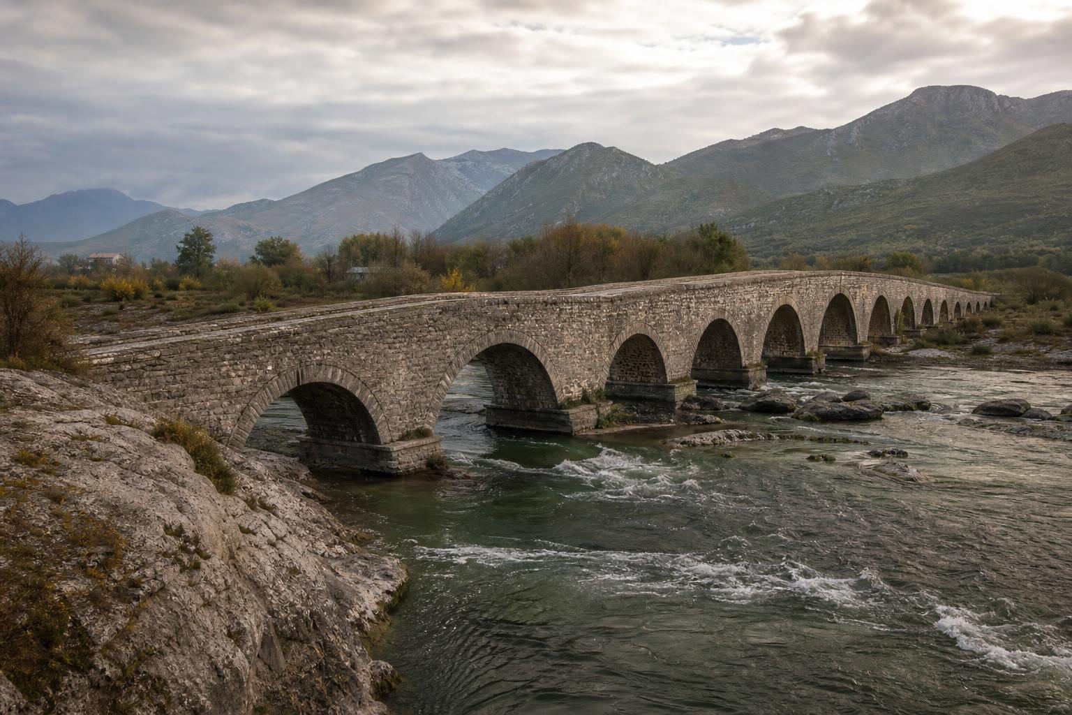
About eight kilometers northeast of Shkodra, a low road curls out of the city, runs past Lake Shkodra’s eastern edge, and drops into the narrow valley of the Kir. The river is shallow most of the year and ferocious for a few weeks every spring. Where the valley pinches between two limestone hills, a long thin line of pale stone crosses the water — Ura e Mesit, the Mes Bridge, named for the village it sits in.
It is 108 meters long. It carries thirteen arches. It has stood for roughly two and a half centuries, since the late 1760s, when the Bushati pashas of Shkodra commissioned it to connect their capital to the inland trade routes east toward the Drin and on to Kosova. Today it is one of the most photographed pieces of Ottoman-era architecture in Albania, and one of the few that has remained continuously in use — for pedestrians, anyway — since the day it opened.
For Albanian-American readers visiting Shkodra, the bridge is often the first stop after the castle of Rozafa. It photographs well. It is also, on closer inspection, a precise object: a piece of late-Ottoman provincial engineering commissioned by an autonomous Albanian dynasty, built without mortar in most of its mass, sized for a specific river’s flood behavior, and aimed at a specific economic problem. This piece is the longer explanation of what it is and what it means — for the region, for the late Ottoman period, and for how the diaspora can read a single stone span as a chapter of Albanian history.
What and where: the basic geography
The bridge is in the village of Mes (sometimes spelled Mesi, which is also how the bridge’s name is rendered: Ura e Mesit — literally “the bridge of Mes” or “the middle bridge”). Mes is a small settlement in Shkodër County, in the administrative unit of Postribë, about 8 kilometers (5 miles) northeast of Shkodra along the road toward Drisht and the Drin valley.
It crosses the Kir River (Albanian: Lumi i Kirit), a tributary of the Drin that drains the western slopes of the Albanian Alps and the Postribë hills before joining the Drin near the city of Shkodra. The Kir is a short river — under 50 kilometers — but it is fed by steep mountain catchments and behaves as a typical Mediterranean flash-flood stream. For most of the year, it runs clear and shallow under the bridge; for a few weeks each spring and after major rainstorms, it can rise several meters within hours.
The bridge sits at one of the few points on the Kir’s lower course where the valley narrows enough to make a stone crossing economically feasible. The geology helped: limestone outcrops on both banks gave the builders solid anchor points for the abutments and a nearby source of cut stone.
Who built it: the Bushati pashas of Shkodra
To understand why a 108-meter stone bridge appeared in this valley in the 1760s, you need to know about the Pashalik of Shkodra — the semi-autonomous Albanian dynasty that ran northern Albania for roughly seventy-five years.
The pashalik was founded by Mehmet Pasha Bushatlliu (also written Mehmet Pasha Bushati, or in Ottoman documents Mehmed Pasha) around 1757. The Bushati family was one of the powerful Muslim Albanian landowning households of the Shkodra region, and Mehmet Pasha used a combination of military success, marriages, and Ottoman court connections to consolidate control of the northern Albanian highlands. By the 1760s, he was effectively running the region as his own provincial state, paying nominal tribute to Istanbul but conducting his own administration, his own justice, and — increasingly — his own foreign policy.
The pashalik would last until 1831, when Ottoman forces under Reşid Mehmed Pasha finally suppressed the last Bushati ruler, Mustafa Pasha Bushati, after a long siege of Shkodra Castle. In between, three generations of Bushati pashas — Mehmet, his son Kara Mahmud Pasha, and grandson Mustafa — ruled an Albanian territory that at its peak stretched from Montenegro’s coast to inland Kosova.
Mes Bridge dates to the founding generation. Conventional dating places its construction around 1768, during Mehmet Pasha’s tenure. Some sources, including Albanian heritage publications, also credit Kara Mahmud Pasha (ruled c. 1778-1796) with completing or extending the works. The dating is imprecise because Ottoman-era provincial construction records for the region are thin; what is well-established is that the bridge is Bushati-era and falls in the second half of the 18th century.
The Bushati pashas were not only military operators. They invested in mosques, fortifications, caravansaries, and roads across their territory. A bridge of Mes’s scale was an infrastructure project a sovereign state would commission — and that is, in effect, what the late-period pashalik was.
Why it was built: the road to Kosova
Shkodra in the 1760s was the largest city of northern Albania and one of the most important commercial centers of the Ottoman western Balkans. It sat at the meeting of three trade systems: the Adriatic coast, the lowland routes south toward Tirana and central Albania, and the inland route east through the Drin valley to Prizren, Peja, and Kosova.
The eastern road was the chokepoint. To move goods or troops from Shkodra inland, traffic had to cross the Kir within the first hour out of the city. For most of the year that was easy — a ford in the right place did the job. For roughly six weeks each spring and after major storms, the river was uncrossable. Caravans backed up, perishable goods spoiled, and the pashalik’s ability to project authority into its eastern districts evaporated until the water came down.
A permanent stone crossing solved several problems at once. It made the route reliable in all seasons, which was decisive for commercial trade. It shortened the effective distance between Shkodra and Prizren — historically the second major Albanian-inhabited Ottoman city — by removing the seasonal closure. It gave the Bushati administration faster military reach into Kosova. And it broadcast a political signal: that the pashalik had the resources, the engineering capacity, and the long time horizon to build something on this scale.
Mes Bridge was not a tourist amenity. It was a piece of state infrastructure for a state that was not, on paper, supposed to exist.
The engineering: thirteen arches and the math of flood
A long bridge across a flash-flood river has a specific engineering problem: it has to let high water through without being swept away. The 18th-century Ottoman provincial answer was many small arches rather than one large one.
Mes Bridge has thirteen arches along its 108-meter length. The central arch is the largest — roughly 22 meters in span and the highest above the riverbed, sized to clear the main channel where the Kir runs deepest. To either side, the arches step down in span and height, following the floodplain’s profile. The smallest flanking arches at the ends are only a few meters across; they exist to carry the deck over secondary channels and overflow areas that come alive only during major floods.
The result is a structure that lets the river breathe. During an ordinary winter, only the central arch carries water. During a serious flood, the river spreads across the full width of the floodplain and passes through every arch simultaneously — including the small ones that are dry land for fifty weeks of the year. The pressure on any single pier stays manageable. The arches share the load.
The construction is dressed-stone masonry — limestone blocks quarried locally, shaped to fit, and laid without mortar through much of the structural mass. The arches are true voussoir arches, with wedge-shaped stones locking into the keystone at the crown. The piers between the arches are solid stone with shallow cutwaters on the upstream side to deflect debris and reduce the river’s lateral force during floods.
The deck is paved with stone and rises in a long shallow camber toward the central arch — the characteristic “humpback” profile of Ottoman bridges across the Balkans. Pack animals could climb it; modern wheeled vehicles cannot. That profile, combined with the deck’s narrow width (about three meters between parapets), means Mes was always built for foot traffic and pack animals rather than carts. The width tells you something about late-18th-century overland commerce in this part of the empire: it moved on the backs of horses and mules, not on wheels.
Surviving 250 years of floods, earthquakes, and neglect
Two and a half centuries is a long time for a stone bridge in a seismically active region with a flash-flood river under it. Mes Bridge has needed work; it has never failed.
The Kir delivers a major flood roughly once a decade and a catastrophic one every generation or two. Each event has tested the bridge. The arch-and-pier design has held up because the river’s energy gets distributed across thirteen openings rather than concentrated against a single wall. The masonry has absorbed scour damage at the base of piers and required repointing and partial rebuilding of cutwaters, but the structural integrity of the arches themselves has held.
Earthquakes are the more dramatic test. The Shkodra region sits on the Shkodra-Peja seismic line, the active boundary that produced the magnitude 6.4 earthquake on 26 November 2019 centered offshore from Durrës — the most destructive Albanian earthquake in modern times. Shkodra felt the 2019 event strongly. Mes Bridge came through with no recorded structural damage. The 1979 Montenegro earthquake, with an epicenter much closer to Shkodra, was also survived. Older 19th- and 20th-century quakes in the region have left documentary traces of damage to specific Shkodra buildings but no record of major damage to Mes.
The reason is the same as the flood resilience: a multi-arch stone bridge with no rigid frame can absorb a remarkable amount of ground motion. The arches flex slightly, the stones shift fractionally, and the structure settles back. A reinforced-concrete bridge of the same span built in the same location in the 1960s would have required substantial post-earthquake assessment in 2019. Mes did not.
The bigger threat to the bridge over its history has been neglect rather than disaster. During the Albanian communist period (1944-1991), the bridge was not destroyed — communist Albania broadly preserved Ottoman-era infrastructure when it was still useful — but maintenance was sporadic. Post-1991, with the road bypassed by a modern vehicle bridge upstream, Mes lost its functional role and became purely a heritage object. Conservation work has been performed in stages, including significant restoration in the 2000s under Albanian and international heritage programs.
Preservation status today
Mes Bridge is designated a Monument of Culture of the First Category under Albanian heritage law, the highest level of legal protection for built heritage. The designation restricts modifications, requires Ministry of Culture approval for any conservation work, and prioritizes the bridge’s historical integrity over its functional use.
The conservation challenges are familiar to anyone who works with Ottoman stone bridges across the Balkans: sediment buildup under the smaller arches reduces flood capacity; erosion of pier foundations during high water requires periodic underpinning; graffiti and minor vandalism affect the parapets; and agricultural runoff and seasonal flooding deposit material against the upstream cutwaters. None of these are existential threats, but they require steady attention.
The bridge is not a museum object behind glass. Visitors walk across it freely. Locals from Mes still use it as the village’s primary footbridge. Wedding photographers and visiting Albanian-American families crowd the deck on warm weekends. This live, low-key use is part of the bridge’s character — and arguably part of what has kept it intact. A structure with daily users gets watched. Loose stones get reported. Cracks get noticed.
The Albanian state has periodically discussed more elaborate visitor infrastructure at Mes — parking, interpretive signage, a small visitor center. So far, the bridge has been left mostly alone. That is probably the right call. The thing that makes Mes worth visiting is the bridge itself in its valley, not the apparatus around it.
Reading the bridge: what it tells us about Ottoman Albania
A piece of architecture this old, this complete, and this specific to its time and place is also a historical document. Mes Bridge tells you several things about late-Ottoman northern Albania that are harder to extract from texts.
It tells you the Pashalik of Shkodra had capital, engineering expertise, and confidence in its own permanence. You do not commission a 108-meter stone bridge if you expect your administration to collapse next year. The Bushatis were planning in generations.
It tells you the economic axis of the pashalik ran east, not just along the coast. The expensive infrastructure went on the road to Kosova because that was where the trade was — Albanian wool, livestock, and agricultural products moving inland in exchange for textiles, manufactured goods, and silver moving the other way. The Adriatic coast was important; the inland route was the cash flow.
It tells you that Albanian provincial autonomy in the late Ottoman period was real, not a paper category. The Ottoman state did not commission Mes Bridge. The Bushati family did, using local labor, local stone, and local engineering tradition, on a road that served their own administrative and commercial purposes. Istanbul knew about it and did not stop it, but it was an Albanian project in every operational sense.
And it tells you something about Ottoman-era Albanian craftsmanship. The masonry is excellent. The arches are precisely cut. The cutwater geometry is sophisticated. The bridge was not built by an itinerant Ottoman master imported from Istanbul; it was built by stonemasons who knew the local geology and the river’s behavior and who had probably worked on smaller crossings elsewhere in the region for decades. Albanian stone-bridge building was a developed regional skill, not a one-off.
Mes in the wider family of Albanian stone bridges
Albania has a handful of surviving Ottoman-era stone bridges that matter for the country’s architectural heritage. Mes is the largest by length and arch count, but it does not stand alone.
The Goricë Bridge in Berat (Ura e Goricës) is the most internationally visible of the group, because it sits within the UNESCO World Heritage zone of Berat. The current Goricë Bridge was rebuilt in 1780 by Ahmet Kurt Pasha to replace an earlier wooden crossing. It is shorter than Mes — about 130 meters total but with only seven arches — and structurally distinct.
The bridges of the Drin tributaries — smaller crossings at Vau i Dejës, in the Mat valley, and elsewhere along the inland trade routes — share Mes’s general construction logic: multi-arch dressed-stone bridges sized for flash-flood rivers. None match Mes for scale.
The Tabhane Bridge in Tirana, the Terzive Bridge (also in Berat), and several smaller crossings in southern Albania add to the surviving Ottoman-era inventory. Many more were lost — to floods, to modernization, to wartime destruction, to neglect during the communist period.
Mes is the largest, the most architecturally complete, and the most visually striking of the surviving group. That status, plus its accessibility from a major city, is why it ends up on the cover of Albanian heritage publications more often than the others.
Visiting Mes from the diaspora
For Albanian-American readers planning a trip to Shkodra — or for those who have already been and want to fit Mes into a wider sense of the region — the bridge is a 15-minute drive from the city center along the road toward Drisht and Theth. Public transport runs in the form of furgon minivans heading northeast out of Shkodra; private taxis cost a few euros each way.
There is no admission fee, no fence, no opening hours. The bridge is simply there. Locals from Mes will be using it. Visitors crossing the deck for the first time tend to notice the same details: how narrow it is, how shallow the camber feels until you reach the central arch, how the stone has worn into small saddle-shaped depressions where two and a half centuries of footfall have polished it down.
The diaspora resonance is worth naming. For many Albanian Americans, especially second- and third-generation visitors whose families left after 1991 or earlier, Shkodra is a city heard about more than seen. Older relatives may have visited the bridge as children, in the years before mass emigration. The bridge becomes a place where family memory and physical place line up. That intersection is a large part of what makes heritage travel work: standing on something that your grandparents stood on.
The bridge does not perform that role. It just continues to be a bridge — well-built, weathered, useful at small scale, and visibly older than any of the political arrangements currently in place. Heritage objects of this kind tend to outlast the regimes that build them and the diasporas that visit them. Mes is one of those.
A note on names and dates
A few naming conventions are worth pinning down for anyone reading further about the bridge.
Mes vs. Mesi: the village is Mes; in some Albanian grammatical cases the form becomes Mesit (“of Mes”), which appears in Ura e Mesit (“the bridge of Mes”). English-language sources sometimes render the bridge as “Mesi Bridge,” which is a half-translated form. “Mes Bridge” or “Ura e Mesit” are both correct. The slug for this article uses mesi-bridge because that is the most common search-form rendering in English.
Mehmet Pasha Bushatlliu vs. Mehmet Pasha Bushati: same person, different transliteration. Bushatlliu is the formal Albanian masculine suffix form; Bushati is the simpler English-rendering of the family name. Ottoman documents use Buşatlı Mehmed Paşa. All three refer to the founder of the Pashalik of Shkodra.
Date: ~1768 is the conventional Albanian heritage-record date for the bridge’s construction. Sources vary; the construction was almost certainly a multi-year project, and some sources give 1770 or 1773 instead. The pashalik-era second half of the 18th century is the well-supported window.
Continuing the heritage record
Albanian heritage in the US diaspora is largely sustained by what families teach at home and what community organizations choose to remember. Mes Bridge is one of those reference points — a piece of architecture old enough to predate every modern political dispute about Albanian identity, and concrete enough to walk across. If you want to be counted as part of the community that keeps this record going, the National Albanian Registry is the place to start.
The bridge will be there either way. The community that knows what it is, and why it matters, is the part that needs the work.